Works Departments is required to submit Geographic Information System (GIS) data to the Lands Department (LandsD) if the contract sum of a construction project is over HK$30M. However, if the scope of the works project does not involve any change of the position or alignment of features shown on LandsD’s 1:1000 Topographic Map, submission of the GIS data is not required.
Frequently Asked Questions about Collation of Geospatial Data
General
In the design stage, only the building outlines and road margins covered in the 1:1000 Basic Mapping Specifications are required to be updated on LandsD 1:1000 Topographic Map for GIS data submission. In the as-built stage, all as-built features covered in the 1:1000 Basic Mapping Specifications are required to be updated on LandsD 1:1000 Topographic Map for GIS data submission.
The 1:1000 Basic Mapping Specifications provide guidelines for representing data on the paper map and in the database. A full copy is available for download under the "Resources > Survey Related Guides and Specifications" Section on the LandsD website.
In accordance with the Project Administration Handbook (PAH) for Civil Engineering Works, the Operational Instruction of Architectural Services Department, and the PAH of Electrical and Mechanical Services Department, Works Departments shall submit geospatial data of approved design and as-built surveys to LandsD. Should there be genuine difficulties in compliance with the new requirements, Works Departments may obtain approval for exemption from the D2 or above Officers, and the justifications should be properly documented. LandsD should be duly informed of any such exemption.
Submission of Geospatial Data
The project responsible officer of the Works Department nominates a user from the department/contractor/consultant to be responsible for converting and submitting GIS data to LandsD with the use of Cloud-based Production Mapping Platform (CPMP). LandsD will create an account for the nominated user to access CPMP. Upon successfully registering a CPMP account, the login information to LandsD’s CPMP, along with the detailed guidelines of the CPMP, will be sent to the project officer for converting and submitting GIS data. A document "Submission of GIS Data via Cloud-based Production Mapping Platform (CPMP)" is available on the LandsD website for reference.
Using the CPMP, users nominated by the Works Department are required to submit GIS data, which comply with the LandsD 1:1000 Basic Mapping Specifications, to LandsD for acceptance. The procedure is set out in the guidelines for using CPMP, which is accessible after signing in to CPMP under the CPMP website> Tools> Help.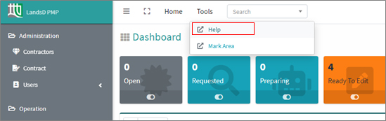
Performing Basic Map Updating and Acceptance Criteria
Demo videos showing the procedures of GIS data conversion and submission are available on LandsD CPMP Help (need to access through LandsD CPMP). Please sign in to CPMP and access the demo video through CPMP website> Tools> Help.
The GIS data submission has to comply with 1:1000 Basic Mapping Specifications.
1:1000 Basic Mapping Specifications is available for download from the LandsD Website. Please refer to Q5 above for details.
After the Works Department/Contractor/Consultant submits GIS data, LandsD will check the submission. The Works Department/Contractor/Consultant may need to revise and resubmit GIS data to LandsD if LandsD identifies irregularities.
No, it is not required to submit raw survey data.
CPMP Account Management
The responsible project officer can contact CPMP support at lispmpsupport@landsd.gov.hk for applying a CPMP user account.
Please contact CPMP support at lispmpsupport@landsd.gov.hk
Data Specification
For common ground features related to GIS data, please refer to "Examples of Updating Features on 1:1000 Topographic Map for Works Department", available on CPMP Help (you need to access it through LandsD CPMP). For details, please refer to 1:1000 Basic Mapping Specifications available on LandsD website.
Computer-Aided-Drafting Standard for Works Projects (CSWP) is the standard to be used in the structuring and naming of features to be stored in Computer-Aided Drafting (CAD) format, while 1:1000 Basic Mapping Specifications of LandsD is the guidelines about the selection of ground features to be surveyed and drawing up definitions of map features and their attributes in GIS.
